
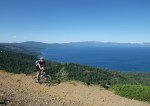
Lake Tahoe’s West Shore is not often associated with epic Tahoe Mountain biking. Among the marquee Tahoe mountain biking destinations (Mr. Toads, the Flume Trail, Northstar, Hole in the Ground, etc), the West Shore is often overlooked. Make no mistake though, there is great mountain biking here as well.
For our non-mountain biking blog readers- check out the pics. Peaks, ridges, and flowers, oh my. Of course, all of these areas make for great hiking and running as well. A photo gallery is at the end of this post.

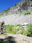
Descending through Mule’s Ears from Stanford Rock
Consider this a “teaser” of the riding on Tahoe’s West Shore. In the coming weeks, I’ll post more in-depth information about several of our favorite rides along with GPS routes. As always with our ride suggestions- do your own reality check. For mountain biking (and other recreational activities) in Tahoe, I recommend the Adventure Maps Lake Tahoe Basin map.

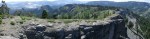
The cliffs of Knee Ridge on the Ellis Peak trail
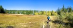
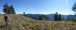
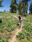
Page Meadows/Scott Peak

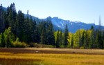
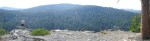
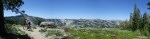
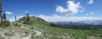
Admiring the Panoramic views to the South of Scott Peak
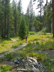
Located at approximately 7,100′ elevation, Page Meadows is about two miles from Tahoe City along the Tahoe Rim Trail. Page Meadows is a series of meadows separated by “islands” of tree stands. The area is criss-crossed with neighborhood social trails, and you can spend a couple of hours exploring stands of aspens or meandering around. Page Meadows is a great place to see aspens turning in the fall, as well as spring wildflowers. It is also a popular xc skiing and snowshoeing areas, when you can cross easily from meadow to meadow.

Page Meadows in the Fall- blazing aspens and mountain peaks
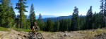
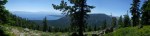
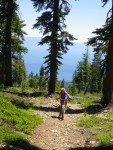
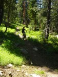
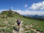
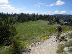
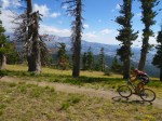
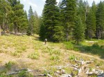
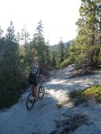
One of our favorite rides is to ride up Ward Creek Blvd onto the Tahoe Rim Trail, up to Scott Peak at 8,200′, then return for a fast singletrack descent back into Tahoe City. Scott Peak is another under appreciated ride. Much of the climb to Scott Peak is on old overgrown logging/jeep roads before turning to proper singletrack. The old roads have effectively detoriated into singletrack. The last mile of the climb has fantastic views in almost every direction. Atop Scott Peak, there are panoramic views in every direction. Great wildflowers in June and July as well. It is possible to ride to Scott Peak from Alpine Meadows via ski access roads. Rather than climb steep, loose ski area service roads, we prefer to ride to Scott Peak as an out-and-back on singletrack.

H climbing to Scott Peak
I found these two pictures taken in the same spot in Page Meadows a few months apart. Fall and spring- a tale of contrast. A cool “accident” in photography.

Page Meadows in Spring

Page Meadows in Fall
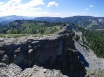
Stanford Rock/Ward Canyon

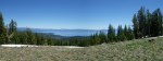
View from the top. Looking East from Stanford Rock
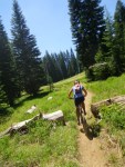
Stanford Rock is one of the West Shore’s more popular rides. It is also one of the longer sustained climbs in the Tahoe Basin climbing from Lake Level to 8,400′ over 5.5 miles (about 2,200 feet vertical with few breaks). The descent down to Ward Creek Blvd is a spectacular and challenging one. Because of poorly spaced stone stairs and a few steep loose rocky sections, this is a descent for the technically savvy rider. Don’t forget to stop and check out the views; there are fantastic views of Twin Peaks, aspens, wildflowers, and a large waterfall. Because the descent on a north facing aspect of Ward Canyon, the area is often full of wildflowers late into the year.

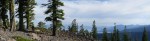
Climbing to Stanford Rock

Climbing to Stanford Rock (the flattest spot on the entire climb)
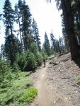
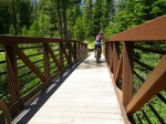
The best access to Stanford Rock is from Hwy 89 in Ward Creek State Park. The trail winds along Ward Creek for almost 1.5 miles before turning uphill for the “real” climb to 8,400′
.
.
.
.
.
.
.
.
Ellis Peak/Barker Pass

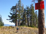
The view when you emerge from the trees! Knee Ridge on the Ellis Peak Trail.

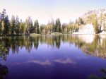
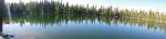
Ellis Lake
The Ellis Peak Trail has some of the most spectacular views in the Tahoe Basin. I have WOW! moments each time I emerge from the trees to the ridge. Pictures and descriptions pale in comparison to actually standing on the ridge. On clear days, there are expansive views deep into Desolation Wilderness on one side, and panoramic views of Lake Tahoe along a cliff on the other side. Bring a camera!

Knee Ridge, Ellis Peak Trail

“Gnome Trail”, aka the Grand Avenue singletrack on the way to Barker Pass
We do this ride as a 20-22 mile loop from our home in Tahoma. The best way is to jump on the singletrack at the end of Grand Avenue (Grand Ave. crosses Hwy 89- do a map check), which parallels Barker Pass road and deposits you at the foot of the Barker Pass climb. We do the 3.5 mile paved climb to Barker Pass before jumping onto the Ellis Peak Trail. The first 1/2 mile of the Ellis Peak Trail is a very challenging climb. It is totally rideable, but requires a few stops to catch your breath. Climbing the OHV road to Barker Pass is not recommended unless you like pushing your bike uphill (its nickname is “Lost Breakfast”; an apt description if you are headed uphill).

Rarely seen views of Tahoe from the East side of Ellis Peak
From Ellis Peak, there is a trail on the East side of Ellis Peak that skirts the edge of Homewood ski area and deposits you into the Homewood neighborhood. There are panoramic views of Lake Tahoe and Quail Lake for much of the descent as well. The Forest Service installed large drainage dips (aka big jumps) which makes for a thrilling descent. We usually leave the fire road and take one of the neighborhood connector trails into Homewood. There is a fun 1.5 mile singletrack descent that deposits you onto Meadow Ave- site of the grandstands for the 1960 Winter Olympic XC ski course (look for a well used, unmarked neighborhood trail on the left side of Noonchester Road).
Ellis Lake is only a half mile detour and worth a visit as well. It lies in the shadow of Ellis Peak and often has mirrored reflections of Ellis Peak on its surface.
Sugar Pine Point/General Creek/Lost Lake/Tahoma

General Creek Trail
Sugar Pine Point State Park one major trail that is well suited for mountain biking. Sugar Pine Point State Park was also the location of the 1960 Winter Olympic cross country and biathlon events, and there are a number of historical markers scattered throughout the park’s trails. The main trail in Sugar Pine is the General Creek Trail which runs from the lake into Desolation Wilderness. General Creek runs the gamut from smooth and foresty, to loose and rocky. For those riding to Lost Lake or Richardson Lake, be aware that there is a 6-10 minute hike-a-bike section as the trail climbs through a steep canyon. We usually ride from Richardson Lake back to Sugar Pine State Park Additionally, there are a number of connector trails into the park from Tahoma.

Lost Lake
Lost Lake is another West Shore gem. A few parts of the Lost Lake trail are in serious need of a re-route. Parts of Lost Lake trail are an old eroded jeep road that runs straight up the hill (it needs the addition of a few switchbacks to be rideable in both directions). Expect a few uphill hike-a-bike sections on the way to Lost Lake. It’s entirely rideable downhill for a technically savvy rider and worth the trip.

General Creek Trail
Like many neighborhoods in Tahoe, this area is littered with neighborhood social trails that criss-cross the area between Sugar Pine Point State Park and Homewood ski area. The trails are in common use by hikers/runners/mountain bikers in the neighborhood. Almost every dead end street in the neighborhood has a singletrack connector into the neighborhood trail network. The number of loops you can do is staggering. We regularly ride 20-25 mile loops of mostly singletrack without ever being more than a few miles from our front door.
Tahoe City

Tahoe Rim Trail near Tahoe City
Looking at a map of Lake Tahoe, Tahoe City appears to be located on the West Shore of Tahoe. Despite its appearance, Tahoe City is really considered to be the “corner” between West and North Shores.
There is absolutely epic riding in the Tahoe City area for all skill levels and distances. The Tahoe Rim Trail from Tahoe City to Brockway has fantastic mountain biking: long climbs and fast descents, great views, and terrain ranging from smooth and flowy to rocky and technical. While Tahoe’s East shore is known for it’s sandy, granite lined trails, Tahoe City is more forested. Additionally, there are miles and miles of trails littered throughout the area. Burton Creek State Park has so many miles of trails and unmarked intersections, that it took us years to make sense of it. There are so many miles of trails, that it’s possible to do 20-50+ mile rides of mostly singletrack. It would take several blog posts to cover all the trails in the Tahoe City Area.
You can read about one of our favorite Tahoe City rides here: Mt Watson, Western States, and the Tahoe Rim Trail (27 miles, mostly singletrack).

Cliffs on the Tahoe Rim Trail above the Truckee River
Meeks Bay South to Fallen Leaf Lake
Mountain biking south of Meeks Bay is not well developed. There are a number of great (non-bike legal) hiking trails, but it is a very rugged area that borders Desolation Wilderness. While there are a few sections of bike legal trail, The terrain south of Meeks Bay is better suited for hiking and backcountry skiing. This area has great potential.
More Pics of West Shore Mountain Biking
-
- Page Meadows in the Fall- blazing aspens and mountain peaks
-
- Panoramic views in every direction- looking east from Scott peak
-
- Tahoe Rim Trail near Tahoe City
-
- Cliffs on the Tahoe Rim Trail above the Truckee River
-
- Climbing to Scott Peak
-
- H climbing to Scott Peak
-
- Atop Scott Peak
-
- Southern view from Scott Peak
-
- Climbing to Stanford Rock (the flattest spot on the entire climb)
-
- Climbing to Stanford Rock
-
- Lake Tahoe views on a steep loose section
-
- View from the top. Looking East from Stanford Rock
-
- The bridge over Ward Creek
-
- “Gnome Trail”, aka the Grand Avenue singletrack on the way to Barker Pass
-
- The view when you emerge from the trees! Knee Ridge on the Ellis Peak Trail.
-
- Knee Ridge, Ellis Peak Trail
-
- The cliffs of Knee Ridge on the Ellis Peak trail
-
- Ellis Lake
-
- General Creek Trail
-
- General Creek Trail
-
- Rarely seen views of Tahoe from the East side of Ellis Peak
-
- Lost Lake
-
- Descending Lost Lake Trail
Share this:


Your photos never disappoint in making me extremely jealous and making me want to load up the bike and head to Tahoe. It’s just such a different landscape than we ride in here in Oklahoma/Arkansas. I love the wide open spaces and miles of view you have in every direction. Great work.
LikeLike
I have to say I’m kind of surprised that you don’t have more “like”s or comments. Maybe I’m partial to the mountains, and absolutely love Tahoe… but still. Great content and, beautiful pictures! You might enjoy another website titled: http://dreamingoftahoe.wordpress.com/ Take care, keep up the good work, and I look forward to seeing more of your blog!!
LikeLike
Thanks for the kind words. Writing a blog is interesting. The posts I’ve written that I’ve been most proud of are not always the most read or “liked.” I have a zillion topics to write about, and not enough time to do it. Winter and short days are more conducive to writing an outdoor blog. Otherwise I I try to be outside till the sun goes down. Thanks again.
LikeLike